

TAO Jinhuaa,1, FAN Menga, YUAN Yeb,c, WANG Weiyed, WANG Zhibaoe, PAN Pengxuf,2,*, CHEN Liangfua
a. State Key Laboratory of Remote Sensing and Digital Earth, Aerospace Information Research Institute, Chinese Academy of Sciences, Beijing, 100101, China
b. Heilongjiang Provincial Emergency Rescue Support Center, Harbin, 150036, China
c. Northeast Forestry University, Harbin, 150040, China
d. Guangdong Provincial Disaster Prevention and Mitigation Center, Guangzhou, 510600, China
e. Bohai-Rim Energy Research Institute, Northeast Petroleum University, Qinhuangdao, 066004, China
f. Heilongjiang Provincial Forest and Grassland Fire Prevention Early Warning and Monitoring Center, Harbin, 150090, China
Abstract
Forests are hailed as the lungs of the Earth and serve as a critical pillar for maintaining ecological balance. However, against the backdrop of intensifying global climate change, extreme heat, and frequent droughts, wildfires have become one of the most serious disasters threatening global ecological security, biodiversity, and the safety of human life and property. How to monitor and control wildfires efficiently and precisely is a major challenge confronting all countries. As a country rich in forest resources, China has invested continuously in wildfire monitoring in recent years. Recent years has witnessed the development of a distinctive “space-air-ground” multidimensional wildfire monitoring system integrating ground monitoring, satellite remote sensing and AI-supported screening: a “Chinese solution” for wildfire monitoring in the protection of East Asian forest resources. Owing to the monsoon climate and complex terrain, East Asia faces a high risk of cross-border wildfire spread and daunting governance challenges. This effective monitoring paradigm constructed by China provides an important and feasible reference for addressing regional ecological security challenges and promoting cross-border joint prevention and control.
Keywords
wildfire monitoring, space-air-ground multidimensional monitoring system, multi-source data fusion, AI agent system
Cite this article as
TAO Jinhua, FAN Meng, YUAN Ye, WANG Weiye, WANG Zhibao, PAN Pengxu and CHEN Liangfu. (2026) From “Human Eyes on Watch” to “Sky Eyes Weaving a Net”: The Systematic Leap of China’s Wildfire Monitoring. Bulletin of the Chinese Academy of Sciences, 40, 2026002. DOI: https://doi.org/10.1051/bcas/2026002
Setbacks of Traditional Monitoring
Wildfire monitoring is an important upstream step and foundational work in the wildfire prevention and control system, and its technical level directly determines the overall effectiveness of early wildfire prevention and control. A review of its development trajectory shows that the essence of wildfire monitoring is the gradual expansion and evolution of humanity’s ability to perceive fire situations. From ground-based manual lookout to aerial patrol to satellite remote sensing detection and high-point video surveillance, the spatiotemporal dimensions of human perception of fire situations have continuously expanded. However, constrained by the inherent limitations of technical means, single-dimensional monitoring approaches have never been able to overcome three fundamental limitations: insufficient full-domain coverage, delayed fire response, and persistently low identification accuracy.
First, insufficient full-domain coverage: ground-based monitoring methods such as manual patrols, lookout tower observations, and high-point video surveillance are generally constrained by terrain and vegetation occlusion, leaving numerous visual blind spots; aerial patrols are limited by flight costs and meteorological conditions, making long-term, large-scale monitoring difficult; satellite remote sensing is constrained by revisit cycles and cloud cover, also leaving temporal and spatial blind spots. Second, delayed fire response: manual information relay involves multiple administrative levels and long chains, and hence suffers from poor communication, which easily leads to delayed responses; satellite monitoring is limited by complex, time-consuming processing procedures, which similarly delay the response. Third, persistently low identification accuracy: manual visual observation struggles to distinguish fire smoke from natural phenomena such as clouds and haze; video recognition algorithms easily misjudge direct sunlight, cloud reflections, and interfering heat sources, while rain, snow, frost, and dust obscuring lenses also reduce recognition rates; satellites are limited by resolution and struggle to detect small fires, and high-temperature interference sources such as agricultural burning and industrial and mining heat sources lead to the long-term coexistence of false alarms and missed detections. Each single technical path has insurmountable shortcomings in application, and the data formats and communication protocols of these paths are inconsistent and incompatible, preventing monitoring systems from forming consistent synergies. Wildfire monitoring has therefore long faced the passive situation of incomplete coverage, high false alarm rates, and delayed responses, making it difficult to meet the urgent needs of modern wildfire prevention and control.
Multi-dimensional Monitoring System
To break through the bottlenecks of traditional monitoring, China has actively explored and implemented a “space-air-ground” multidimensional intelligent wildfire monitoring system. On the basis of a multidimensional perception network featuring space-based all-weather full-coverage patrol, air-based regular patrol of key areas, and ground-based timely verification at key points, and with the support of artificial intelligence (AI) technology, a systematic reconstruction has been achieved, aiming to build an all-weather, highly accurate wildfire early-warning system with few blind spots. In terms of space-based monitoring, relying on more than 20 polar-orbiting and geostationary remote-sensing satellites, including China’s Environmental Disaster Reduction series, Gaofen series, Fengyun series, and related meteorological satellites recommended by the World Meteorological Organization, a high-frequency, high-precision, wide-area hotspot monitoring network that combines high-, medium-, and low-resolution sensing with visible and infrared detection has been constructed. It conducts all-weather scanning of vast forest areas in East Asia, with more than 200 scans per day. While monitoring the entire territory of China, this wide-area space-based network can also provide fire warning support for neighboring countries in East Asia. To address the challenge of small-fire identification, research institutions have developed dedicated satellite retrieval algorithms to improve the ability to capture incipient fires. In terms of air-based monitoring, aerial monitoring systems composed of various manned and unmanned aircraft have become a key force in filling the gaps of space-based monitoring. These systems patrol fire situations in key areas and during key periods according to planned routes. Equipped with visible light and thermal infrared sensors, and through air data links, they can complete fire reconnaissance and transmit real-time imagery of the fire scene back under complex terrain conditions, providing high-precision maps for ground-based firefighting. Some aircraft carrying firefighting equipment can directly extinguish fires, achieving efficient “reconnaissance and fire-suppression integration.” Air-based monitoring largely solves the problems of satellites being unable to see clearly, ground crews being unable to reach the site, and response times being long. In terms of ground-based monitoring, local fire prevention management departments fully consider differences in terrain, vegetation coverage, phenological characteristics, and other factors, and scientifically plan and deploy large-scale facilities such as manual lookout towers, video surveillance stations, and fire-danger factor monitoring stations in key protection forest areas. Meanwhile, professional forest rangers conduct regular mountain patrols according to planned routes. These fixed facilities, mobile forest rangers, and 5G and satellite communication networks constitute a dense ground-based perception system, achieving minute-level all-weather monitoring of forest fire situations, lightning, litter moisture content, soil moisture, and meteorological factors. Ground-based monitoring effectively fills the spatiotemporal observation blind spots of space-based and air-based monitoring.
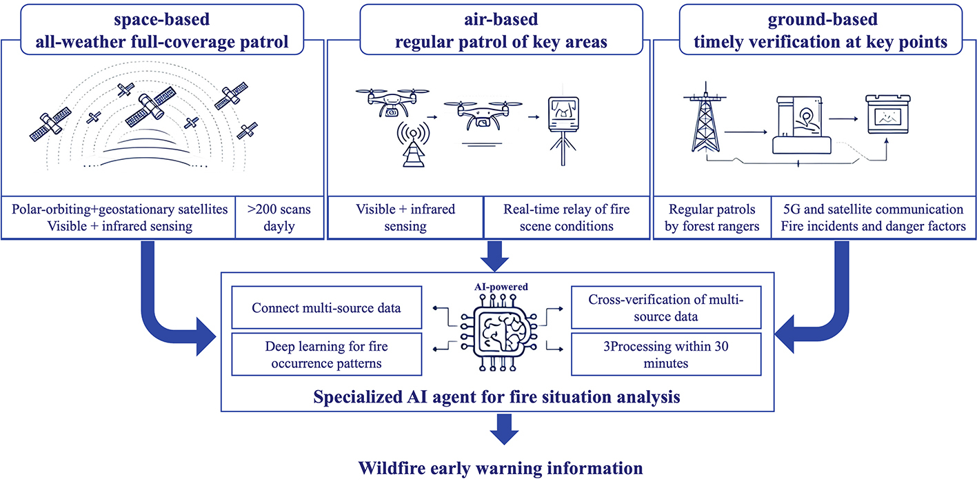
Figure 1. A schematic layout for the “space-air-ground” multidimensional intelligent wildfire monitoring system.
Smart Perception Powered with AI Assessment
If hardware facilities are the skeleton, then multi-source data fusion technology is the soul of this system. In the past, space-air-ground perception information was fragmented and isolated, forming information silos. The development of big data and AI technologies has brought these data to life. The massive volume of data collected by the perception network is extremely complex, and extracting fire information quickly and accurately from this vast amount of data is the central goal of data fusion. Relying on a dedicated AI agent system for fire-situation assessment, built on large AI models such as DeepSeek and supported by high-speed transmission networks and high-performance computing facilities, it is possible to perform comprehensive deep learning on fire-situation characteristics, terrain, vegetation, meteorology, and other environmental factors, and thus to fully grasp the patterns of fire occurrence in different regions. Fire-situation judgment no longer relies on the results of a single sensor; space-air-ground multi-source evidence is comprehensively verified, greatly reducing the false alarm rate of fire situations. The AI agent system can quickly fuse massive heterogeneous data from different sources and accurately identify fire signals, ensuring that the processing delay for even the most complex data does not exceed 30 minutes. To address the difficulty of distinguishing controlled agricultural burning from forest wildfires in agriculture–forestry interface zones during the farming season, satellite data are used to construct and regularly update high-precision land-use maps, the spatial distribution of interfering ground objects, and the combustion and spread characteristics of different fire types, providing high-quality training datasets that help the AI agent improve its identification accuracy and distinguish real wildfires more reliably. This closed loop from “data perception” to “intelligent extraction” to “timely warning” makes wildfires “nowhere to hide.”
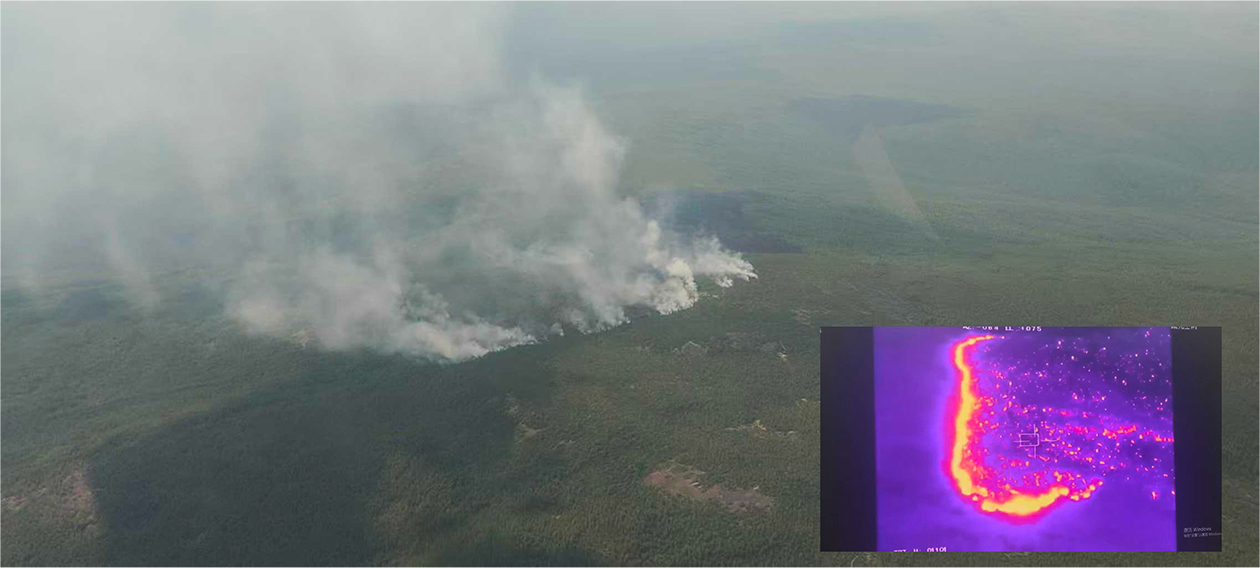
Figure 2. Aerial monitoring of fire situations.
Wide-spread Application
At present, this space-air-ground multidimensional wildfire monitoring system has been widely implemented and verified across various regions of China. Jilin Province has recorded 44 consecutive years without a major forest fire, and the Changbai Mountain Nature Reserve has maintained a record of 65 consecutive years without a major forest fire. The evolution of China’s wildfire monitoring technology from ground-based lookout to a space-air-ground multidimensional intelligent perception system is a history of innovation spanning from “manual surveillance” to “technology-based surveillance,” and a vivid portrayal of technology empowering ecological protection. China has not only consolidated its own ecological barrier but also provided valuable reference for global forest fire prevention and governance.
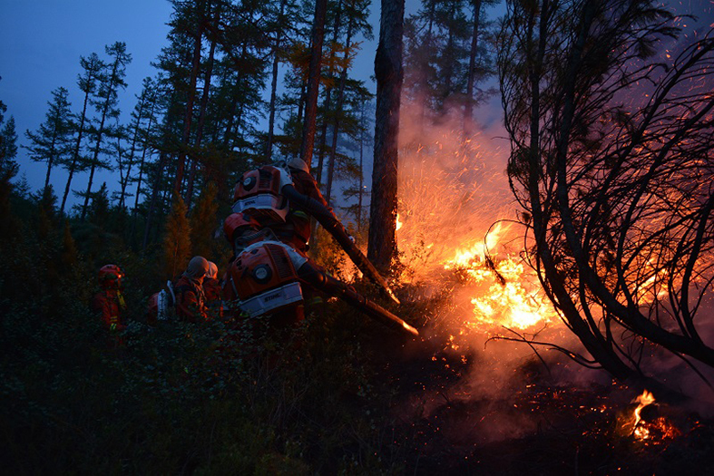
Figure 3. Forest firefighters promptly extinguishing a fire.
Stepwise Upgrade of Perception System
For countries or regions rich in forest resources, with complex terrain, and weak monitoring capabilities, the construction of a smart fire prevention system can evolve in three steps based on existing facilities. Step one: install video surveillance equipment on existing high-point towers, connect satellite fire-point data as a supplement, and fill spatiotemporal monitoring blind spots at low cost. Step two: establish a unified networked platform that aggregates ground-based video surveillance, manual patrols, and space-based satellite monitoring information, introduce preliminary AI screening and drone verification, and form an active monitoring and early-warning capability of “satellite scanning–video surveillance–drone verification.” Step three: reach the comprehensive intelligence stage. Integrate meteorological, vegetation, terrain, and historical fire data; achieve all-weather real-time aggregation of multidimensional perception information from satellites, drones, video surveillance, ground sensors, and personnel; and enable intelligent fire-situation assessment. Through these three steps, the monitoring scope can be gradually expanded, and the degree of data integration and automation can be improved. Each of the three steps can independently yield results, but they need not be implemented strictly in sequence, nor does every region need to complete the entire process. Adaptation should be made to local terrain, vegetation, climate, and communication conditions to build a smart fire monitoring system that meets local needs.
After years of development, this system has significantly improved the performance of early wildfire identification and warning response, but there remain several technical bottlenecks that urgently need to be addressed, such as early satellite detection of small fires, long-endurance and swarm coordination of drones, and communication support and real-time data transmission in complex terrain. These bottlenecks need to be addressed to further enhance the timeliness, accuracy, and full-coverage capability of wildfire monitoring and early warning, and to better serve global forest resource protection and ecological governance.
Reference
Jilin Provincial Forestry and Grassland Bureau. Jilin Changbai Mountain Continues to Write a Green Legend of 65 Years Without Major Forest Fires (In Chinese). https://jllc.jl.gov.cn/xxfb/xydt/tpxw/202512/t20251202_3515671.html
* To whom correspondence may be addressed. Email: hljfgfiremonitor@163.com (PAN P.)
1 TAO Jinhua, Professor at the State Key Laboratory of Remote Sensing and Digital Earth, Aerospace Information Research Institute, Chinese Academy of Sciences, focuses on wildfire satellite remote sensing monitoring technology and its applications. Together with the team, she has developed and established a wildfire satellite monitoring and early warning system based on multi-source satellites. The system has long been applied in various provinces and cities across China, supporting forest and grassland fire prevention and control, straw burning management, and related work.
2 PAN Pengxu, Senior Engineer of the Heilongjiang Provincial Forest and Grassland Fire Prevention Early Warning and Monitoring Center, has long been engaged in the early warning and monitoring of forest and grassland fires in high-latitude cold regions. His major achievements include a number of patents and participation in the formulation of local standards. He has been awarded the title of Advanced Individual in provincial forest and grassland fire prevention on multiple occasions.