WU Bingfang1,2,*, ZENG Hongwei1, YAN Nana1,
ZHANG Miao1, & CHANG Sheng1
1Key Laboratory of Digital Earth Science, Institute of Remote Sensing and Digital Earth, Chinese Academy of Sciences, Beijing 100094, China
2 University of Chinese Academy of Sciences, Beijing 100049, China
ZERO HUNGER has been recognized as a core sustainable development goal (UN 2015). To this end, efforts should be made to increase productivity and production, strengthen capacity for adaptation to climate change, extreme weather and disasters with sustainable food production systems and resilient agricultural practices, and promote food market information transparency to ensure the proper functioning of food commodity markets and to limit extreme food price volatility.
Studies have revealed that regional food insecurity may be aroused with the changing climate, and amplified with non-appropriate human interventions. Countries along the Belt and Road have to contend with longer periods of drought and more intense flooding, as well as water conflicts between sector.
Strategies such as climate-smart agriculture that are designed to counter the impacts of climate change and build better resiliency are now being strongly advocated. Good policies rely on the availability of high-quality, timely, and disaggregated agricultural data, which are sparse in countries with weak statistical systems (ADB 2018).
Earth observation provides the opportunity to study and monitor vegetation, water, natural resources, greenhouse gases etc. on a near-real time basis. By effective use of the knowledge and products emanated from remote sensing and geospatial information, the technology can significantly help mitigate the adverse impacts of natural disasters (UNESCAP 2013) in countries along the Belt and Road. To ensure food security, effective monitoring of crops with accurate, reliable and timely information is necessary for making informed decisions. Although significant progress has been made in the region in the use of remote sensing and geospatial information for agricultural monitoring, not all issues related to crop damage assessment, crop planning and diversification, timely tailoring of agricultural practices and demand for irrigation scheduling have been properly addressed, primarily because of the lack of capacity in terms of human, scientific, technological, organizational and institutional resources.
The Digital Agriculture Team of the Institute of Remote Sensing and Digital Earth (RADI), Chinese Academy of Sciences (CAS) focuses on agriculture, water, and drought monitoring and research, and have accumulated rich experience that could be tailored to the needs of the countries along the Belt and Road, so as to establish a shared agronomic information community for the Belt and Road Initiative(Wu et al. 2017b). Presented here are three examples of its efforts to strengthen food security and livelihoods of vulnerable countries, which will contribute to the Sustainable Development Goals through enhanced access to digital early warning monitoring information for climatic shocks, trans-boundary water issues and geo-referenced production forecasts.
CropWatch for Mozambique1
CropWatch has served as a world-leading crop monitoring system for assessing national and global agro-information and crop production using remote sensing indicators. It is a cloud-based platform allowing voluntary participation and contribution as well as independent monitoring and analysis of interested stakeholders across the world. Developed by RADI on the basis of decades of research and advance in satellite-based remote sensing, CropWatch (Wu et al. 2014; Wu et al. 2015) provides periodically agricultural information for the globe. Quarterly Bulletins released by CropWatch has been downloaded by users and stakeholders from 149 countries and regions, contributing to the satisfaction of global need for more reliable, transparent, and up-to-date information on agricultural production to fight against hunger across the world.
Mozambique is facing serious food insecurity issue with low crop production and fast population increase. Strengthening agricultural monitoring can improve its policy making process in a scientific way.

CropWatch training for national and provincial experts of Mozambique
Under joint support of the Digital Belt and Road Program (DBAR) and China World Bank Group Partnership Facility (CWPF), a customized CropWatch Cloud platform for Mozambique with Portuguese version has been designed and developed according to agricultural features of this country, which is an open platform that allows voluntary participation from Mozambique.
From April to June 2018, experts from the Ministry of Agriculture and Food Security of Mozambique (MOAFS) worked on agricultural monitoring for Mozambique and major production provinces with CropWatch Cloud. The monitoring results achieved by two experts from national and Nampula provincial offices of MOAFS using CropWatch Cloud were officially incorporated into the Mozambique National Agro-Meteorological Bulletin in June 2018 (Figure 1).
Through participating in CropWatch Cloud, experts from MOAFS are able to do agricultural monitoring for whole Mozambique or by province (Figure 1). Its Minister highly appreciated the assistance of CropWatch for Mozambique, recommending building a team of expertise to visit RADI for sustainable development, and organizing internal technical discussions to use the CropWatch as surveillance tool for supporting decision making in Mozambique.
Figure 1 Mozambique National Agro-Meteorological Bulletin for June 2018 (NDVI profile and NDVI based condition map on page 3 was generated using CropWatch Cloud Platform)
The customized CropWatch Cloud and capacity building process have not only assisted S&T workers in Mozambique and improved their monitoring ability, but also promoted ownership and innovation on agriculture monitoring. It offers a unique opportunity for the country to work on crop monitoring without considering storage and computational resource. CropWatch Cloud can be easily customized for other developing countries following the same strategy.
ETWatch for Egypt2
ETWatch is a powerful evapotranspiration (ET) monitoring system based on remote sensing and six core algorithms developed by the ETWatch team of RADI: net radiation, soil heat flux, sensible heat flux, latent heat flux, gap filling and ET data fusions. The system provides the processing chain for the daily ET at the 100m, 250m, and 1km resolution and 5–30m resolution for required time interval. It is the first operational platform in the world with well-managed data and extensibility, guarantying the series ET data production ET is an important parameter of water cycle for water resource management and irrigation management departments (Wu et al. 2012; Wu et al. 2016; Wu et al. 2017a).
Egypt is one of the driest and sunniest countries in the world with an average annual precipitation of 50–200mm. Water is the most important factor restricting the sustainable development of the Egyptian economy. Quantitative observation or measurement of water consumption is the basis for water management and decision-making. Evapotranspiration is the real amount of water resources loss, and its accuracy measurement is the priority for effective water resource management.
Through cooperating with the World Bank, RADI started to customize and transfer ETWatch to National Aerospace and Remote Sensing(NARSS) Egypt in 2016. Currently, ETWatch has been installed and operated in National Authority for Remote Sensing & Space Sciences of Egypt (NARSS). Particularly NARSS has set up an ET excellence center to produce ET data for Egypt with ETWatch. A technical training for Egypt NARSS technicians and researchers was carried out from September to November in 2016. As an important output, Egypt technicians worked out the calibrated parameter sets for Egypt areas together with ETWatch team at RADI collaborators. A comparison between estimated daily ET with 250m resolution and eddy covariance (EC) observations at New Salhia station showed that the mean absolute error (MAE) was 0.83, the root mean square error (RMSE) was 1.10 and index of agreement (d) was 0.94.
Evapotranspiration data with 30m resolution covering the study area from 2014 to 2015 were produced during the technical training period.
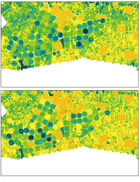
Figure 2 Annual ET map in east area of New Salhia in 2014 (top) and 2015 (bottom)
Figure 2 showed that ET spatial maps of east area of New Salhia with modern irrigation equipment, such as sprinkler and drip irrigator. It was very obvious that the areas with sprinkler circle consumed more water in 2014 than 2015. The analysis indicated that more or less water consumption mainly depended on cultivated times in one year.
ETWatch was customized and used for training workshop for Ministry of water resources and irrigation in Egypt in 2017.
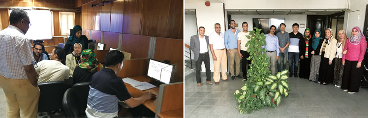
The training workshop of ETWatch-Egypt system at the National Authority for Remote Sensing & Space Sciences of Egypt, 30th September–4th October, 2017
Water resource management based on water consumption is attracting extensive attention in the world, particularly in the arid, semi-arid and semi-humid area. Coping with water scarcity, new technologies are needed for the water resource management. After successful cooperation between RADI and NARSS, ETWatch is being extended to the Mediterranean countries as Jordan, Lebanon, Morocco, and Tunisia. In future it will be extended to more countries along “the Belt and Road” facing serious water crisis.
DroughtWatch for Mongolia3
DroughtWatch is a drought monitoring system developed by RADI (Yan et al. 2016; Wu et al. 2016; Wu et al. 2015). After 20-year improvement, DroughtWatch becomes a multi-satellite, multi-scale drought monitoring system. It provides the real-time agricultural drought information, including the drought occurrence, development, and changes. It enables satellite data processing, drought monitoring, statistics, and analysis and data management. Its outputs can be represented in the form of database, document, table, curve, histogram and graph, etc. The DroughtWatch batch processing make the operational use efficient with low inputs on time, capital and resources.
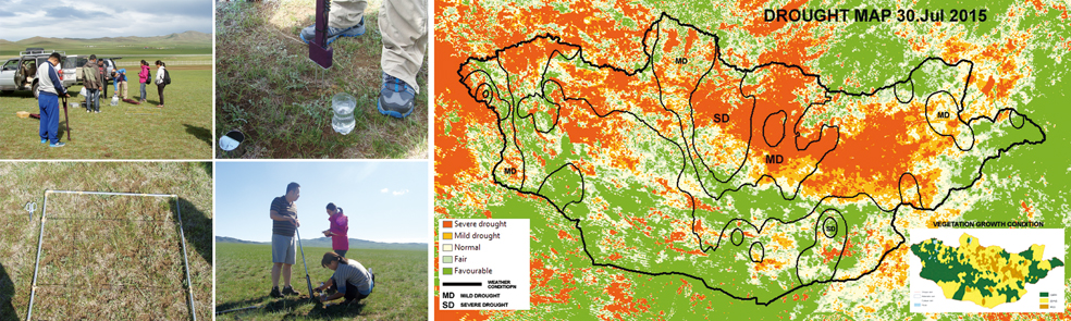
Drought is a main nature disaster in Mongolia, befalling its 30–70% areas each year. It affects agriculture, livestock productivity, water resources and natural vegetation, causing enormous economic losses. It also accelerates the desertification of the grassland areas in Mongolia. Currently, the timeliness and accuracy drought information for mitigation and disaster managements is urgent required by Mongolia.
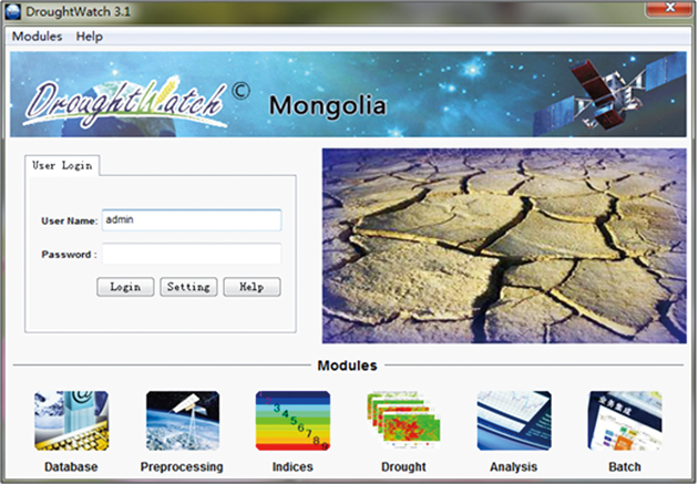
Figure 3 The main interface of DroughtWatch-Mongolia
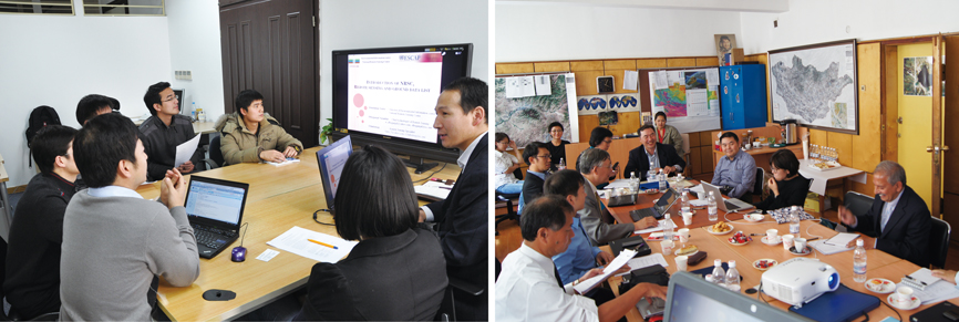
With the support of CAS-TWAS and UN ESCAP regional drought mechanism, customized DroughtWatch was deployed in the Mongolian National Remote Sensing Center (NRSC) of Information and Research Institute of Meteorology, Hydrology and Environment (IRIMHE) of Mongolia in 2014 and has been operated by NRSC staff for four years (Figure 3)(Chang et al. 2017). After two years of development and four years of validation as well as five years of training and capacity building, DroughWatch for Mongolia is fully functional, providing services and meeting local operational requirements. Within this platform, three zones were divided according to the ecosystem and land cover features of Mongolia, more than 10 monitoring indicators were integrated based on satellite data after considering climate, hydrological, terrain, and agricultural practice characteristics. Dynamic monitoring information has been disseminated to ministries and counties in support of crop, forest and pastoral animal husbandry sectors, for pasture rotationally in animal husbandry sector and rational planning for hay making, for irrigation and fertilization of agricultural crops and their optimal planning, for preventing from forest fire and pest infestation as well.
Joint field work and validation
On September 17, 2018, the DroughtWatch-Mongolia developed by RADI researchers was officially handed over to the Mongolian National Remote Sensing Center (NRSC).
Currently, DroughtWatch has been used in countries as Cambodia and Sri Lanka, and the future will focus on other drought-prone countries in Central Asia.
Operation training and workshop about DroughtWatch-Mongolia
As a result of successful pilot in Mongolia, and joint academic research and system transfer with Cambodia and Sri Lanka, a Standard Operation Procedure (SOP) for Regional Collaborative Mechanism on Drought Monitoring and Early Warning in Asia and the Pacific has been formulated. DroughtWatch has become a typical demonstration and recommendation system for the drought mechanism of UN-ESCAP in Asia-Pacific areas.
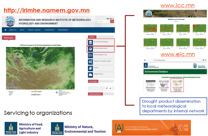
DroughtWatch-Mongolia Product and services dissemination to users
Outlook
This is only the first step for assisting countries along the Belt and Road to enhance their information accessing ability. In order to enhance their capacity on resilient agriculture practices using remote sensing, an agriculture and food security working group (DBAR-AGRI) was established in 2017 with its mission to set up a shared information and knowledge community for the Belt and Road Initiative through technical transfer and joint research to address the information gap related to zero hunger. The Launching Ceremony of the DBAR International Centre of Excellence on Agriculture and Food Security (ICoE-Lusaka) was held in Lusaka of Zambia in June 2018, which focuses on food security, water resources, and environment degradation issues of SADC regions. We wish ZERO HUNGER can be achieved early in these countries, where resilient agriculture practices on remote sensing monitoring have played an important role.
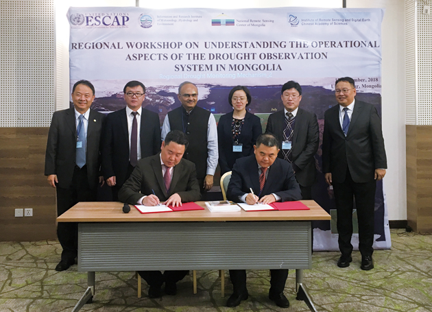
Ceremony of DroughtWatch-Mongolia handover